
The Best Hiking Trails in Georgia
Explore Hiking TrailsTop 28 hiking trails in Georgia
Page 1 of 2
1
Dauset Nature Trails Loop
The Dauset Nature Trails are one of the most venerable mountain bike trail systems in the Atlanta Metro Area. Despite having been around for decades, the local SORBA chapter has been diligent with trail building and maintenance over the years, and newly built or refurbished trails help keep Dauset fun and entertaining....
2


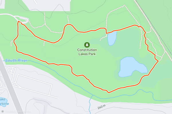
Doll's Head Trail
If you're looking for a creepy Halloween hike, look no further than the Doll's Head Trail in Dekalb County's Constitution Lakes Park, just south of downtown Atlanta. This short hike is known for the weird artifacts planted through the woods, such as bricks, toys, and other things you might not expect....
3
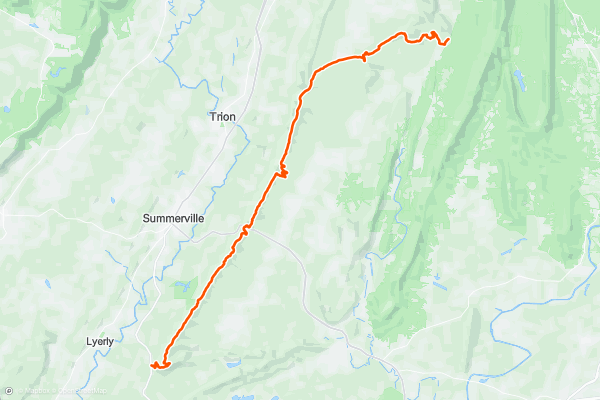
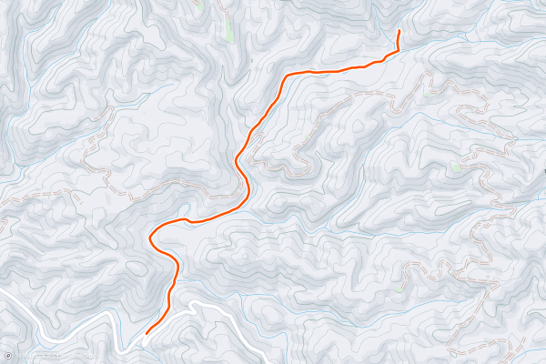
Pinhoti Trail: High Point Trailhead, GA to East Armuchee Road
This Georgia segment of the 330-mile-long Pinhoti Trail is one of the easier portions of the trail as it passes through Georgia. While much of the route follows old logging and forest service roads, rugged singletrack still provides challenges, and some seasonal views can be expected....
4
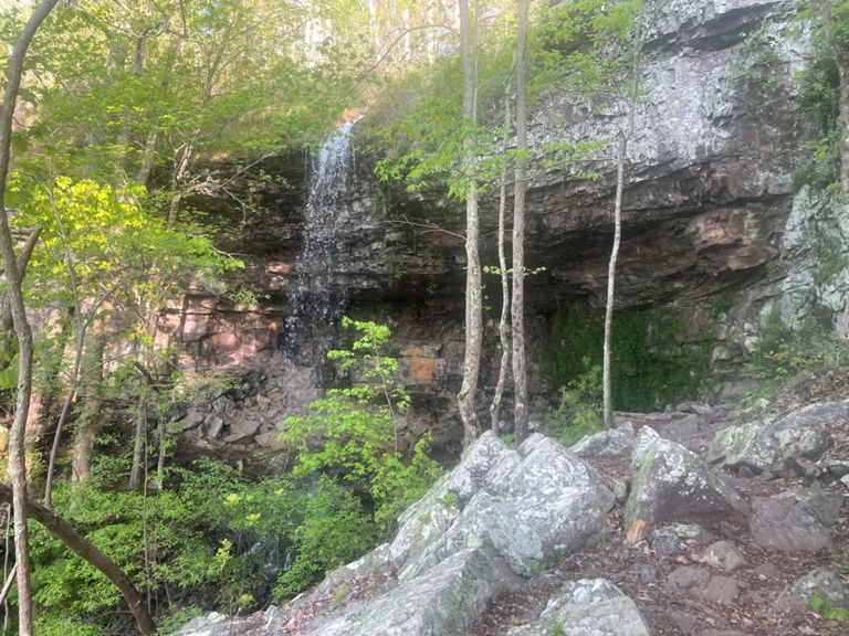


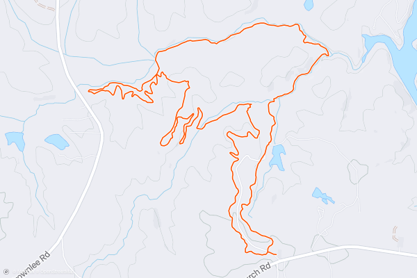
Johns Mountain and Keown Falls
This family-friendly day hike pairs an excellent overlook to a beautiful waterfall and shares part of the route with the 330-mile-long Pinhoti Trail. There are several variations to this loop, and there is no wrong way to hike it....
5


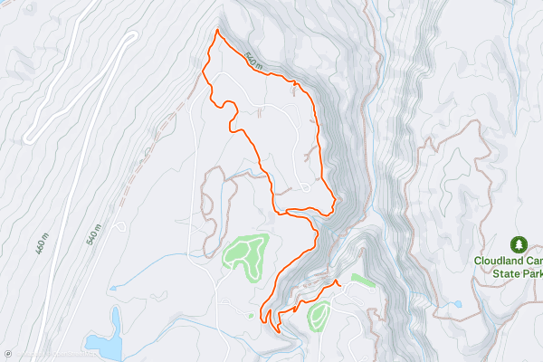
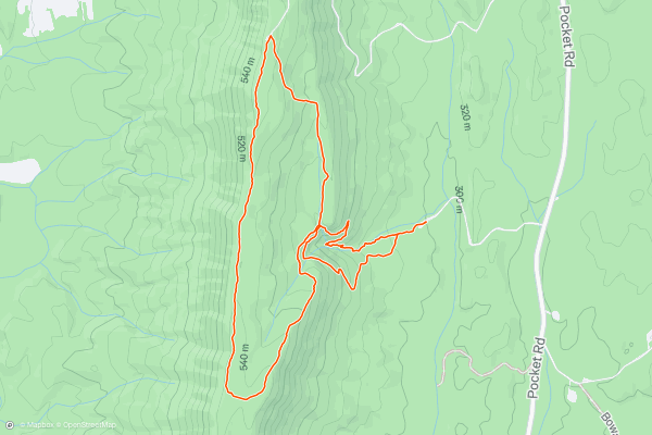
Cloudland Canyon: West Rim Loop
Located in the far northwest corner of Georgia lies one of the state's best-kept secrets: Cloudland Canyon State Park. Situated slightly west of Lookout Mountain, this 3,500-acre state park is a quick drive from Chattanooga and a perfect day trip from Atlanta....
6


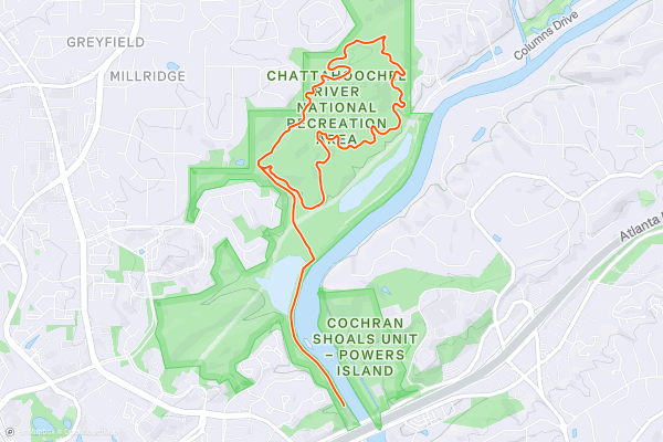
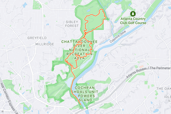
Cochran Shoals
Cochran Shoals is one of the most popular hiking trails in the greater Atlanta metro area. Located in the Chattahoochee River National Recreation Area, this beautiful wooded natural area provides a delightful respite from the crush of traffic and mayhem found in the city....
7
Sope Creek
If you are looking for a getaway close to home, the Sope Creek Trail is a great option for hiking, biking, or running.
This hiking trail takes you to the historic ruins of a Civil War-era paper mill on the banks of a scenic creek, and then to a serene pond surrounded by wildflowers....
8


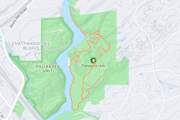
East Palisades Trail and the Bamboo Forest
The East Palisades trail is one of the most scenic Atlanta hikes found inside the perimeter, or ITP, as the locals say. The main leg of this hike traverses along the banks of the Chattahoochee River's Palisades section, "one of the river’s most scenic in metro Atlanta," according to [AtlantaTrails....
9
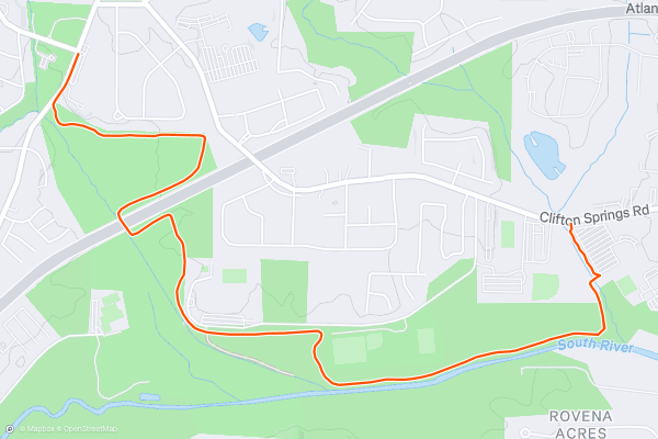
Michelle Obama Trail
The Michelle Obama Trail, just to the south-east of Atlanta, is a scenic pathway that honors the former First Lady's dedication to health and fitness initiatives.
It runs (pardon the pun) for about 3....
10


Springer Mountain Loop
If you're looking to visit the North Georgia Blue Ridge, this is a perfect 1-2 hour hike and great for the entire family. According to atlantatrails.com, this loop is one of the top hikes near Ellijay and has a little to offer for everyone....
11


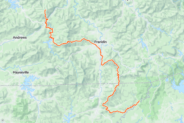
Raven Cliff Falls Trail
The Raven Cliff Falls Trail is a charming hiking trail that leads you through the lush forests of the Chattahoochee National Forest to the stunning Raven Cliff Falls.
The trailhead is located near Helen, Georgia, and provides access to the 5-mile out-and-back trail....
12


Emery Creek Falls
Less than an hour from Ellijay or Chatsworth, Emery Creek Falls is a beautiful hike through historic logging areas leading to a two-part waterfall deep in the forest. It's perfect for the entire family, including the dog....
13


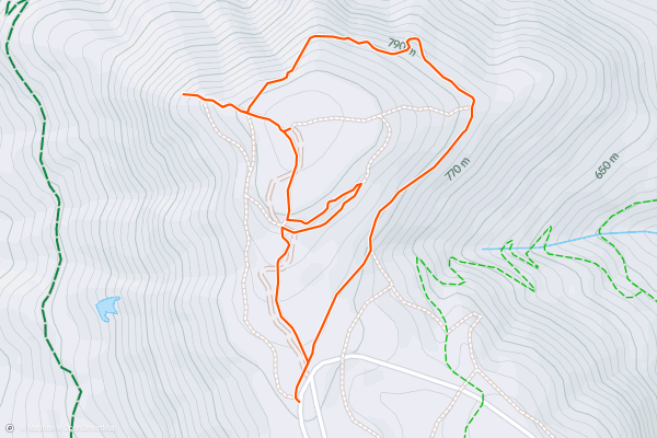
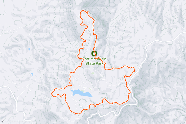
Fort Mountain Summit Loop
With backcountry hiking trails, historical landmarks, mountain biking, horseback riding, and plenty of camping, Fort Mountain State Park is sure to have something for everyone. This short hike explores several of the park's iconic landmarks including a lush overlook, 40' stone fire tower, and the ruins of a ancient rock wall....
14


Gahuti Mountain Trail
Translated as 'Mother Mountain' in the Cherokee language, the Gahuti Trail is one of the best hiking loops in the state park. Compared to Trail 301, another popular route, this is a foot-traffic only trail that highlights Fort Mountain's best features....
15


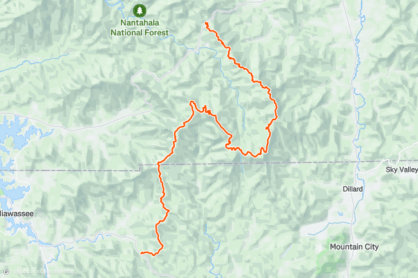
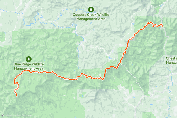
Appalachian Trail: Dicks Creek Gap to Winding Stair Gap
For those looking for a multi-day hike, most people would suggest dividing this section into 3 or 4 days. The trailheads are only a 45-minute drive from each other, making this an easy shuttling opportunity for those looking to bag some of the first 5,000-foot peaks of North Carolina....
16


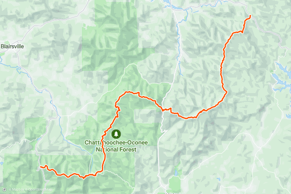
Pinhoti Trail: Snake Creek Gap to Dug Gap
This is arguably the most renowned portion of the 330-mile-long Pinhoti Trail. Popular day hikes are accessible from either trailhead, and the segment is perfect for a shuttled hike. Overnight camping options are also available along this segment, though there are no developed campgrounds....
17
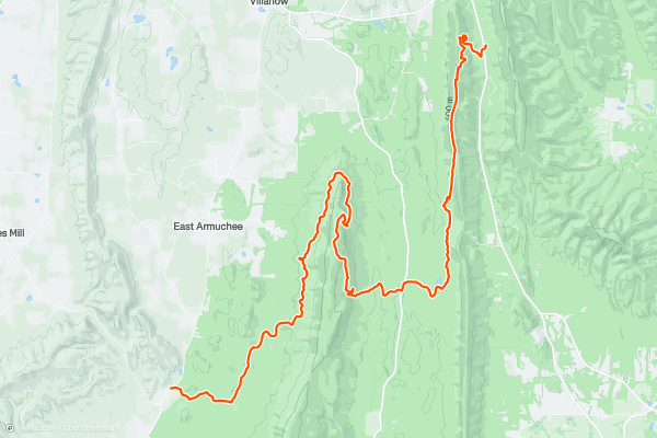
Pinhoti Trail: East Armuchee Road to Snake Creek Gap
This segment of the 330-mile-long Pinhoti Trail begins at a small trailhead along East Armuchee Road. There is a gravel pull-off with adequate parking for a few cars, and the nearby Dry Creek Equestrian Trailhead serves as secondary parking....
18


Bartram Trail
The Bartram Trail is an epic long-distance backpacking (or fastpacking) route through the Appalachian Mountains of North Georgia and North Carolina. If you're not feeling up for a thru-hike, many sections of this trail can be used for day hikes or trail runs....
19


Appalachian Trail: Springer Mountain to Neels Gap
This is the introduction to the nearly 2,200 mile long Appalachian Trail, a trail conceived by the late Benton MacKaye. Completing the entire trail is a mammoth undertaking that shouldn't be taken lightly....
20


Appalachian Trail: Neels Gap to Dicks Creek Gap
Beginning at the parking area at Neels Gap, the Appalachian Trail climbs towards a breathtaking segment of trail which serves as a great segue, continuing beyond Blood Mountain.
For those looking for a shorter day hike, Levelland Mountain, Turkeypen Mountain, Rock Spring Top, Corbin Horse Stamp, Wolf Laurel Top, and Cowrock are all within a 5-mile hike of the trailhead....
Page 1 of 2
Top regions for hiking trails on Strava
- Acadia National Park
- Alabama
- Alaska
- Albuquerque
- Alyeska
- Angeles National Forest
- Arizona
- Arkansas
- Austin, TX
- Bay Area
- Bend
- Big Sky
- Blue Mountain Ski Area
- Boston
- Boulder, CO
- Brevard
- Bridger Bowl
- Buena Vista
- California
- Cape Cod
- Colorado
- Connecticut
- Dahlonega
- Downieville
- Ellijay
- Flagstaff
- Florida
- Georgia
- Glacier National Park (USA)
- Grand Teton National Park
- Great Smoky Mountains National Park, TN
- Hawaii
- Hurricane
- Hyalite
- Idaho
- Illinois
- Indiana
- Kansas
- Kentucky
- Lake Tahoe
- Las Vegas, NV
- Los Angeles, CA
- Maine
- Mammoth Mountain
- Marin County
- Maryland
- Massachusetts
- Maui, HI
- Michigan
- Minnesota
- Missouri
- Moab
- Montana
- Mount Rainier National Park
- Mt. Rainier National Park, WA
- Nederland
- Nevada
- New Hampshire
- New Jersey
- New Mexico
- New York
- New York, NY
- North Bridgers
- North Carolina
- North Dakota
- Oakridge
- Ohio
- Oklahoma
- Oregon
- Park City and Deer Valley
- Pennsylvania
- Phoenix, AZ
- Placitas
- Portland, OR
- Roanoke
- Salida
- Salt Lake City, UT
- San Diego, CA
- San Francisco, CA
- Santa Fe, NM
- Santa Monica Mountains
- Seattle, WA
- Sedona, AZ
- Sisters
- South Carolina
- South Dakota
- South Lake Tahoe, CA
- Stowe
- Sugarbush
- Sun Valley
- Taos
- Telluride
- Tennessee
- Texas
- Timberline Lodge Summer
- Utah
- Vermont
- Virginia
- Washington
- West Virginia
- Wind River Range
- Winter Park
- Wisconsin
- Wyoming
- Yellowstone National Park
- Yosemite National Park, CA
- Zion National Park, UT